- News and Stories
- Blog post
- Local Initiatives
Volunteer Spotlight: Using Data to Reveal an Untold Story
At the turn of the twentieth century, the Greenwood District in Tulsa, Oklahoma was a thriving, all-Black neighborhood with a central commercial district known as “Black Wall Street.” There, businesses and people flourished; Greenwood was home to a hospital, two schools, several churches, hotels and movie theaters, a library, scores of restaurants, and two Black newspapers.
But over the course of 48 hours in May of 1921, a group deputized by the Tulsa Police Department and working in coordination with the Oklahoma National Guard interned an estimated 6,000 people in three camps, looted and burned 35 city blocks to the ground, and murdered approximately 300 of the neighborhood’s residents. This is the most deadly instance of racial violence to take place in US history (second only to the 1919 Elaine massacre in Arkansas). New evidence suggests that the attack on Greenwood was motivated by a greed for land, and not—as previously theorized—sparked by an encounter between a Black man and a white woman, or a simple act of mob violence.
There’s been renewed interest in the story of the 1921 Tulsa Race Massacre following the centennial anniversary of the event last year—but data on what Greenwood was really like before and after the massacre hasn’t been compiled into one comprehensive map—until now. Recently, the Code for Tulsa Brigade partnered with local organizations and colleges to create a visual map of erasure and resilience in the neighborhood. The project, Mapping Greenwood, is an attempt to tell the story of how the community continues to rebuild and commemorate its history. To learn more about their work, we spoke with Carlos Moreno, Co-Captain of Code for Tulsa and one of the creators of Mapping Greenwood.
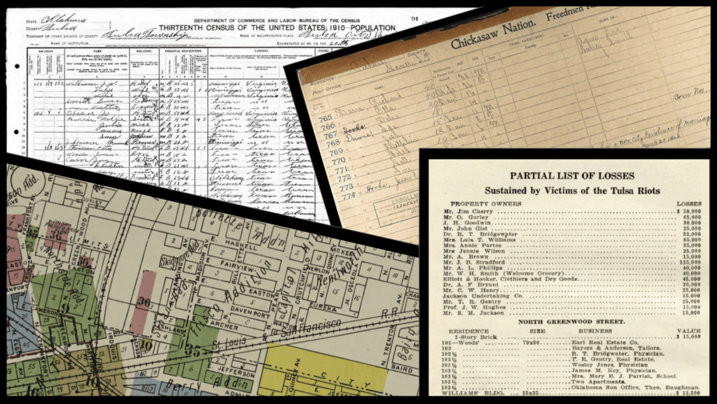
A wealth of scanned documents is helping create a better map of Greenwood.
Tell us a little about how you got involved with the Brigade Network, and how you found this project.
Funny story about how I was introduced to Code for America and the Brigade Network—in early 2012, Luke Crouch showed me Jen Pahlka’s TED Talk, and asked if I’d be interested in starting a Brigade in Tulsa. I said, “Yeah, that sounds really interesting” and he replied, “Good, because I’ve already signed us up and you’re listed on the leadership team!” Since then, we’ve had great success working with nonprofits in the Tulsa community. Building relationships over these 10 years with a few different departments at City Hall made it relatively easy to know where to go when I was looking for land records and historical documents as part of my research for writing The Victory of Greenwood, which tells the stories of twenty prominent families who lived in this neighborhood.
What does the process look like to create a better map of Greenwood?
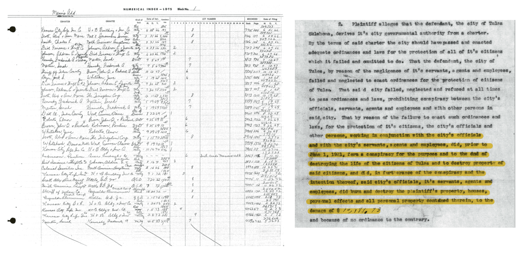
The reality is, there is no comprehensive map of historic Greenwood. In the late 1990s, the State of Oklahoma commissioned the “1921 Race Massacre Commission Report” and it was completed and published in 2001. But the report has only a vague map of Greenwood’s borders. There are still disputes among local historians, academics, and the community about just how large Greenwood was, how many businesses and homes were in the neighborhood before the Race Massacre of 1921, and what the rebuilding of the neighborhood looked like. Over the past five years, land records, census records, business directories, newspaper articles, and ads have been digitized, and so now we have a wealth of raw data to look at. The goal of this project is to take all those pieces of data and weave them into a visual map and timeline of Greenwood so that we can really understand exactly what was in the neighborhood, before and after 1921.
The data we elevate often frames our understanding of a story. How do you think the data you’re compiling will shift our understanding of the story of Greenwood?
Since the 1970s, researchers and academics have focused on Greenwood’s destruction on Memorial Day weekend of 1921, and rightly so. This was an event that was intentionally hidden from history for 50 years, gained some recognition in the early 2000s, but really only became known to the entire nation through the HBO shows Watchmen and Lovecraft Country. There have been books, documentaries, and now a few feature films being developed, but they’re all focusing on this one 48-hour period of Greenwood’s history. What we’ve wanted to do is expand our understanding, especially now that we have this new data that can tell us what homes were here, what businesses existed, which ones came back, and how Greenwood was rebuilt and reshaped after 1921, into the 1940s, 50s, and 60s.
What questions are you most interested in answering about the Greenwood neighborhood?
When we talk about Greenwood (and most historically significant Black communities), we speak of the trauma in specifics—the number of people killed, the number of houses burned, the number of businesses lost, historians, lawyers, and economists try to assess the amount of property damage. But when we talk about Greenwood’s wealth, it’s in the abstract. There were more homes in Greenwood than the 1,256 burned. So exactly how large was Greenwood? Exactly how many businesses were there? How quickly did Greenwood rebuild (we know that by Dec. of 1921, for example, 738 homes were in some phase of rebuilding)? Who lived in Greenwood? We know it was an “all-Black” community, but we also know that white, Latino, Asian, and Jewish families lived and worked in Greenwood. Greenwood’s diversity, community strength, and the ways in which this place succeeded should be highlighted as much as its traumas. The neighborhood’s story deserves to be told in its totality.
Why is it so important now to see the story of Greenwood as a flourishing Black community?
There’s 16mm film footage of Greenwood, and everyone (even the Smithsonian!) assumed that it was from before the 1921 Massacre. But in researching my book, I spoke with a film historian at the Beinecke Rare Book and Manuscript Library where these films are stored, and he explained that 16mm film wasn’t invented until 1924. So these films of Greenwood, and other all-Black communities in Oklahoma, were shot just a few years after this neighborhood had been almost completely destroyed. The footage is beautiful, and you can see the neighborhood is thriving. You’d never guess that this was the site of the deadliest and most destructive act of racial violence in US history. Greenwood built itself back, and to me that’s as inspiring a story as any I’ve ever heard. Count Basie, who would define Jazz from the late ‘20s until well into the 1950s, was inspired not by New Orleans but by Greenwood, after visiting this place in 1927. The DNS registration system was invented by Emmit J. McHenry, who grew up in Greenwood. Though there are a few stories of immense tragedy, there are dozens of inspiring and uplifting stories of how much this place influenced not just Oklahoma, but the entire nation.
What would you like other volunteers to learn from your experience working on this project?
Past civic tech projects involving mapping have tended toward showing resources that residents of a city can locate near them (like the Summer Meals Map), or opportunities where folks can volunteer in their communities (like clearing snow from around fire hydrants, or alerting the city of potholes), or data visualizations (like Chicago’s Million Dollar Blocks project). I’m not aware of a civic tech project that has used land records and historic data to visualize a place from decades ago, and to see it change over time. I’m excited to discover more about Greenwood, and would love to see where else we might be able to map historic places like this.